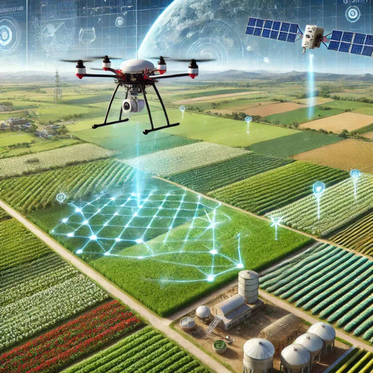
Agriculture has indeed developed from the traditional sowing, watering, and harvesting into today’s technology innovations to monitor and manage crops. In the context of general challenges facing the world today, climate change and increasing population, there is a growing need for precision agriculture, and remote sensing lies at the heart of this revolution.
What is Remote Sensing?
Remote sensing means collecting data about the Earth’s surface without physically touching it through technologies like satellite and drone airborne systems. This information, for agriculture, can tell a farmer how the soil and crops are, the level of water, among many others. This helps one collect information over a wide area, gathering information that would not be possible to gather through manual observations or ground-based surveys.
Main Utilization of Space Remote Sensing in Agriculture
Crop Health Management
Remote sensing may be able to sense the healthy and unhealthy conditions in crops by sensing the light reflected from the leaves of plant canopies. The multi- and hyper-spectral sensors take images of information in different wavelengths of electromagnetic waves that are reflected from crop surfaces. Farmers get early intimation of diseases, pests, and nutrient deficiencies, making it easy for them to step in and stop cropping losses, thus harvesting better crops.
Soil Condition Monitoring
Soil, as a growth factor, is involved with the growth of the crop, and its health condition relies on successful agriculture farming. Remote sensors estimate soil moisture levels, organic matter contents, and nutrient contents. The farmer can optimize irrigation schedules and minimize water wastage by using this information. Fertilizers are applied to crops more efficiently with less over-absorption of fertilizer nutrients by the crops.
Irrigation Management
While there are many resources that have been applied to agriculture, water stands out as one of the most vital, and remote sensing helps the farmer effectively utilize water through the monitoring of evapotranspiration-rates of both water evaporation and plant transpiration-in order to be able to know when and how much their crops will drink water.
Yield Prediction and Planning
With yield prediction with data coming from remote sensing, farmers will be able to provide decisions toward the harvesting time, market strategies, and even resource allocations for the coming cycles. Knowing this will help them better use their labor and machinery and reduce inefficiencies in farming.
Pest and Disease Control
Early detection of pests and diseases is important as it prevents much damage to crops. Remote sensing helps farmers identify areas where plants are stressed because of disease or pest attacks. Thus, it is treated instead of blanket spraying, saving cost and impacts on the environment.
Climate Monitoring
Climate is the most unpredictable aspect of farming. Application of remote sensing will thus afford farm managers with available real-time and historical climate information, which will be instrumental in predicting future raining patterns, frost events, and potential climate-related hazards. With such information, farmers will thus be able to take preventive measures before the crop is actually exposed to extreme conditions either by rescheduling planting or protect crop against such weather conditions.
Types of Remote Sensing Technologies for Agriculture
Satellite Remote Sensing
Satellites offer high coverage and are suitable for even the vast rural areas of farming. They can image at different wavelengths allowing for multi-spectral as well as thermal analysis. However, satellites can be hampered by cloud cover that may limit their view of the ground.
Drones (UAVs)
Drones provide satellite imaging that is far more resolution and extensive. Drones can easily target specific fields, and they capture current data with much flexibility. In the case of drones equipped with sensors for multi-spectral imaging, infrared, and LiDAR (Light Detection and Ranging), one can assess the health of plants, soil quality, and even map out the topography of a given field.
Airborne Sensors
Manned aircraft mounted with cameras and sensors are another middle ground between satellite and drone remote sensing. It has the ability to cover large areas with its resolution at a high level, though at a higher cost as compared to drone-based options.
Advantages of Remote Sensing in Agriculture
Precision Agriculture: Remote sensing enables precision farming through the offering of more accurate and granular information. It allows farmers to intervene in spot areas in their fields, optimize resource use, and maximize yields.
Cost Efficiency: With a reduction in costly physical site visits and manual labor, remote sensing helps in reducing operational costs. Furthermore, it limits excessive use of fertilizers, water, and pesticides through more effective data.
Sustainability: The better resource management remote sensing allows will lead to more sustainable agriculture. A decrease in water wastage, fewer chemicals in the water and on land, and increased proper use of land all lead to environmental protection.
Increased Yields: Quickly identifying problems such as pests, diseases, or nutrient deficiencies allows them to be corrected before impacting yields. This results in healthier crops and eventually in higher productivity.
Challenges and Limitations
While remote sensing revolutionizes agriculture, there are still a few technological challenges. High-resolution satellite images are expensive, and some technologies require a technical knowledge to interpret the data. In most cases, small farmers might lack access to these technologies since they are too expensive or lack infrastructure.
Another limitation comes in terms of dependency on clear weather so that some of these technologies like optical satellite imaging are often obstructed by cloud cover.
Conclusion
Given that it is enabling agriculture to be more intelligent, efficient, and smart, then remote sensing will provide real-time actionable insights that would empower farmers to make better decisions, improve productivity, and reduce impacts on the environment. Feeding the world would surely be a challenge at this growing pace of demand for sustainable farming, but it is in this area that will see remote sensing play very critically in the short term.
As the world is moving towards smart farming, it introduces a lot of remote sensing technologies that are no longer a trend, but a future for agriculture.


